
When it comes to hiking adventures, The Pennine Way stands tall as one of the most iconic long-distance trails in the United Kingdom. Covering approximately 250 miles, this spectacular route traverses some of the most breathtaking landscapes in England and Scotland. In this extensive guide, we will delve into the heart of The Pennine Way, providing you with all the essential details you need to embark on this remarkable journey. From the route’s historical significance to the practicalities of planning your trek, we’ve got you covered.
The Pennine Way: An Introduction
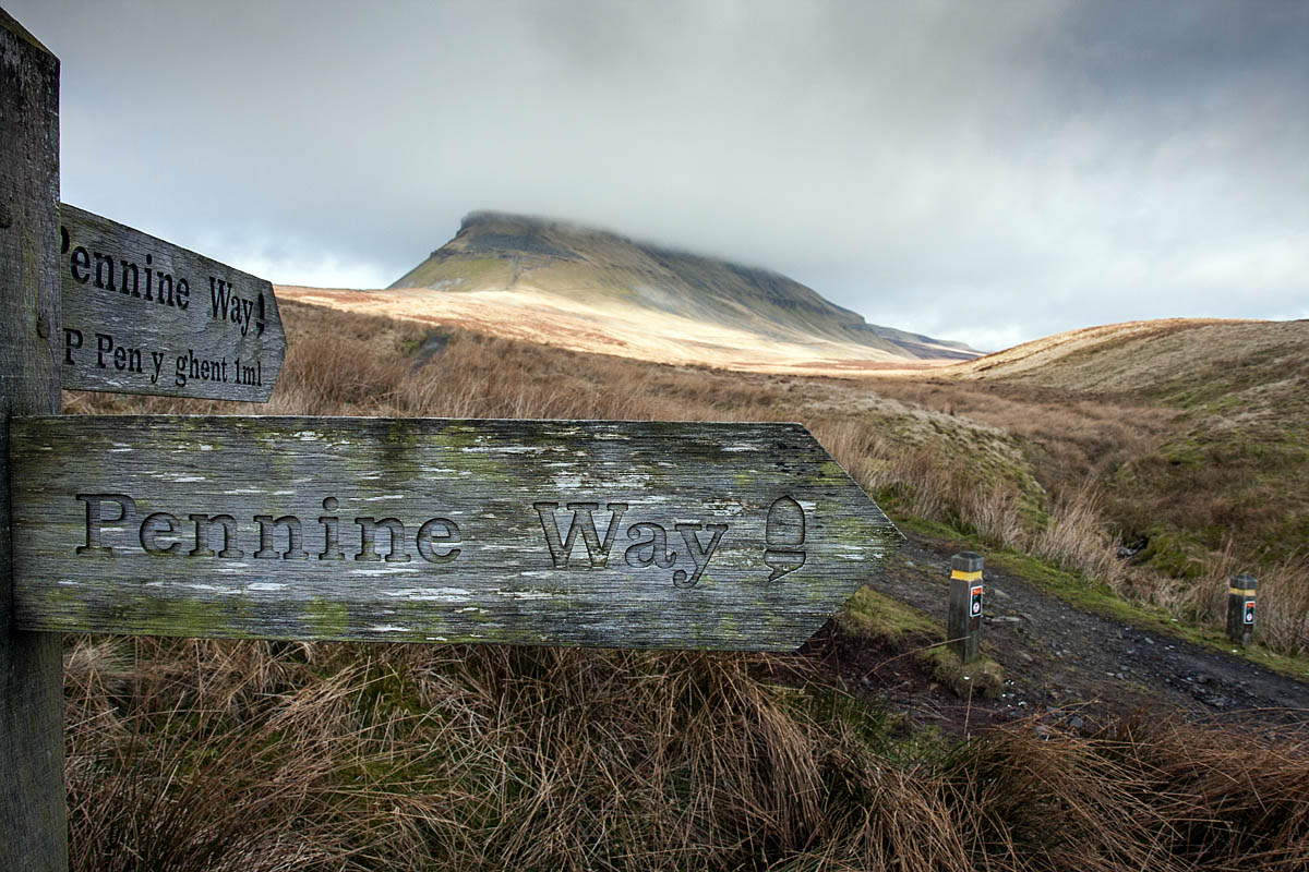
The Pennine Way is a long-distance hiking trail that winds its way through the rugged Pennine Mountains, offering outdoor enthusiasts a chance to explore the beauty and diversity of the British countryside. Established in 1965, it was the very first National Trail in England, and it has since become a beloved destination for hikers seeking an adventure that combines natural beauty, history, and the thrill of a challenging trek.
The Route: From Edale to Kirk Yetholm
The Pennine Way stretches approximately 250 miles (402 kilometers) from Edale in Derbyshire, England, to Kirk Yetholm in the Scottish Borders. This extensive trail meanders through some of the most striking landscapes, including the Peak District, Yorkshire Dales, North Pennines, and the Cheviot Hills.

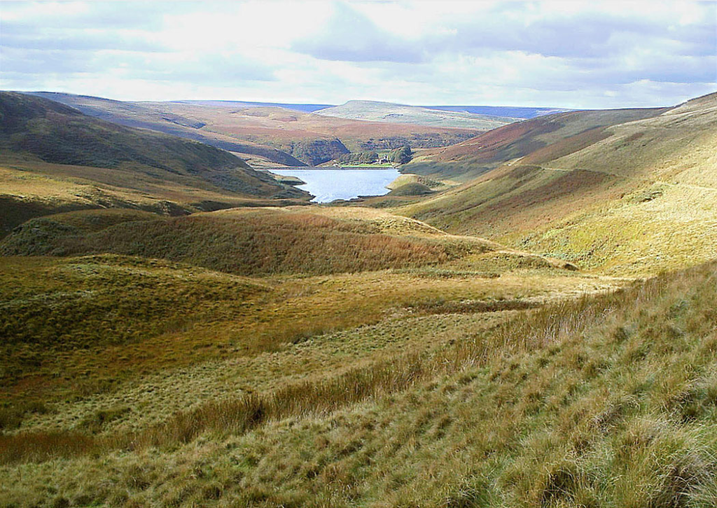
Different Landscapes along the Pennine Way?
One of the highlights of hiking The Pennine Way is the opportunity to witness the stunning landscapes of northern England and southern Scotland. As you journey along the trail, you’ll encounter a wide range of natural wonders, including:
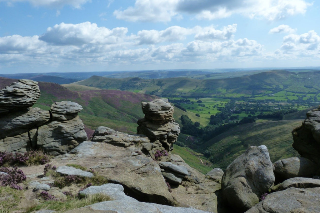
- The Peak District: The trail begins in the picturesque village of Edale, nestled in the heart of the Peak District National Park. Here, you’ll be treated to lush green valleys, rolling hills, and the iconic Kinder Scout plateau.
- Yorkshire Dales: As you progress northward, you’ll enter the Yorkshire Dales, a region characterized by its dramatic limestone landscapes, charming villages, and historic landmarks like Malham Cove and Ribblehead Viaduct.
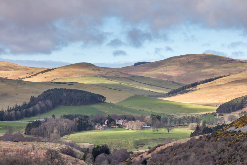
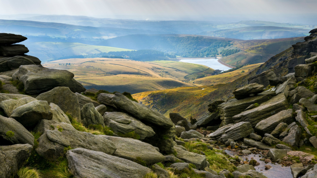
- North Pennines: This section of the trail takes you through the North Pennines Area of Outstanding Natural Beauty, where you can admire the rugged moorlands, wildflower meadows, and the impressive High Cup Nick.
- Cheviot Hills: The Pennine Way concludes in the Cheviot Hills, where you can explore the rolling hills and enjoy panoramic views from The Cheviot, the highest peak in the range.
Is It Easy or Hard?
Hiking The Pennine Way is not for the faint of heart. It’s considered a challenging long-distance trail, primarily due to its rugged terrain and unpredictable weather conditions. The route is known for its steep ascents and descents, boggy sections, and occasional exposure to harsh elements. Therefore, it’s essential to be well-prepared physically and mentally for this demanding adventure.
How to Get There
Before you set off on your Pennine Way adventure, you’ll need to plan your journey to the starting point in Edale. Here are some key details to help you get there:
By Train
The most convenient way to reach Edale is by train. The village is served by the Manchester to Sheffield train line, and there are regular services connecting these cities. Once you arrive in Edale, you’ll find the trailhead just a short walk from the train station.
By Car
If you prefer to drive, Edale is accessible by car from major cities such as Manchester, Sheffield, and Leeds. There are parking facilities in the village, but it’s essential to check availability and any parking fees in advance.
Planning Your Trek: Length and Duration
Trail Length
The Pennine Way spans approximately 250 miles, making it one of the longer long-distance trails in the UK. The exact distance can vary slightly depending on the route you take, but you can expect to cover roughly 15 to 20 miles per day on average.
Duration
The duration of your Pennine Way adventure will depend on your hiking speed, the weather conditions, and how many rest days you choose to take along the way. On average, hikers complete the trail in about 16 to 20 days. However, it’s essential to allow some flexibility in your schedule to account for unexpected challenges and to fully appreciate the scenic beauty of the route.
What to Pack
Packing wisely is crucial for a successful Pennine Way trek. Here’s a list of essential items to consider bringing with you:
- Hiking Boots: Sturdy and waterproof hiking boots are essential for tackling the rugged terrain and keeping your feet dry.
- Weather-Appropriate Clothing: Be prepared for a wide range of weather conditions, including rain, wind, and potentially even snow, depending on the season. Dress in layers and bring a waterproof jacket.
- Backpack: A comfortable and well-fitting backpack is essential for carrying your gear and supplies.
- Navigation Tools: Ensure you have a detailed map, a compass, and a GPS device or smartphone with a reliable mapping app.
- Accommodation: Plan your accommodations in advance, whether you choose to camp, stay in hostels, or book B&Bs along the route.
- Food and Water: Carry enough food and water to sustain you between stops, as some sections of the trail may have limited access to supplies.
- First Aid Kit: A basic first aid kit is essential for treating minor injuries and ailments.
- Emergency Contacts: Keep a list of emergency contacts and inform someone of your itinerary before starting the trek.
Trail Highlights
While hiking The Pennine Way, you’ll encounter a multitude of highlights and points of interest that make this trail a truly unforgettable experience. Here are a few notable highlights along the route:
Kinder Scout
Kinder Scout, located in the Peak District, is known for its dramatic gritstone edges and expansive peat bogs. It’s the highest point in the national park and offers panoramic views of the surrounding landscape.
Malham Cove
In the Yorkshire Dales, Malham Cove is a striking limestone formation that towers over the village of Malham. The cove is a popular attraction and is featured in several films and TV shows.
High Cup Nick
High Cup Nick is a glacial valley in the North Pennines, often referred to as England’s Grand Canyon. The U-shaped valley is an awe-inspiring sight, and you can enjoy breathtaking views from the edge.
Hadrian’s Wall
The Pennine Way briefly follows Hadrian’s Wall, a UNESCO World Heritage Site. This ancient Roman fortification offers a glimpse into the history of the region and provides an interesting diversion from the rugged terrain.
Alston
Alston, a picturesque market town in Cumbria, is a charming stop on the Pennine Way. Known for its cobbled streets and historic buildings, Alston offers a delightful break from the trail. Don’t miss the opportunity to explore its quaint shops, enjoy local cuisine, and soak in the town’s warm and welcoming atmosphere.
High Force Waterfall

Located in the North Pennines Area of Outstanding Natural Beauty, High Force is one of England’s most impressive waterfalls. The Pennine Way takes you close to this stunning natural wonder, allowing you to witness the power and beauty of the cascading waters as they plunge into the River Tees.
Cauldron Snout
Continuing in the North Pennines, you’ll encounter another remarkable natural feature known as Cauldron Snout. This unique formation is a series of cascades and waterfalls formed by the River Tees as it descends dramatically through a narrow gorge. The sound and sight of the rushing water make for a memorable stop on your journey.
Cross Fell

Cross Fell is the highest point in the Pennines and is often shrouded in mist and mystery. Hiking to its summit provides panoramic views of the surrounding landscapes. Be prepared for dramatic weather changes, as Cross Fell is known for its unpredictable conditions, even in summer.
The Schil
As you near the end of your Pennine Way adventure, you’ll reach the Cheviot Hills. One of the highlights in this region is The Schil, a distinctive hill with a steep climb to its summit. The effort is well worth it, as the views from The Schil are nothing short of spectacular, offering a fitting conclusion to your journey.
Border Ridge
Hiking along the England-Scotland border on the Border Ridge is a unique experience. This section of the trail provides a sense of crossing frontiers and is steeped in history. The rugged beauty of the Cheviot Hills surrounds you as you traverse this remote and evocative landscape.
Kirk Yetholm
Your Pennine Way adventure concludes in the picturesque village of Kirk Yetholm, situated in the Scottish Borders. This charming village offers a warm welcome to weary hikers, and it’s an excellent place to reflect on your journey. Take some time to explore the local pubs and learn about the history of this idyllic Scottish settlement.
Pennine Way Heritage
Throughout your hike, you’ll encounter numerous points of historical interest, including ancient ruins, stone circles, and remnants of Roman settlements. The trail is rich in heritage, providing a unique opportunity to connect with the past while enjoying the natural beauty of the present.
Wildlife Encounters
The Pennine Way is not only a treat for hikers but also a haven for wildlife enthusiasts. As you make your way through diverse landscapes, you may have the chance to spot various species of birds, mammals, and plant life.

Keep an eye out for:
- Red Grouse: These plump birds are often seen in the moorlands of the Pennines.
- Curlews: These distinctive birds with long, curved bills are frequently seen in the upland areas.
- Wildflowers: Throughout the trail, you’ll encounter a variety of wildflowers, including heather, bluebells, and orchids.
Challenges and Considerations
While The Pennine Way promises incredible rewards, it also presents certain challenges and considerations that every hiker should be aware of:
Weather
The weather along The Pennine Way can be highly unpredictable, even during the summer months. Be prepared for rain, wind, and rapidly changing conditions. Checking the weather forecast regularly and having suitable clothing and equipment is crucial.
Navigation
Navigation can be tricky, especially in misty or foggy conditions. It’s essential to carry detailed maps and know how to use them. Additionally, having a GPS device or smartphone with a reliable mapping app can provide extra reassurance.
Accommodations
Accommodations along The Pennine Way can fill up quickly, especially during the peak hiking season. It’s advisable to book your accommodations in advance to secure a place to stay each night.
Fitness Level
The Pennine Way is physically demanding, with steep ascents and descents. Prior hiking experience and a good level of fitness are essential. Be prepared for long days on the trail and the mental stamina required for a multi-week trek.
Leave No Trace
As with any outdoor adventure, it’s essential to follow Leave No Trace principles to minimize your impact on the environment. This includes packing out all trash, avoiding trampling on delicate vegetation, and respecting wildlife.
Best Time to Hike The Pennine Way
Choosing the right time to hike The Pennine Way is crucial for a safe and enjoyable experience. The trail is typically open year-round, but the best time to embark on this adventure is during the summer months, from late May to early September. During this period, you can expect milder weather and longer daylight hours.
Spring and autumn can also be good times to hike, but be prepared for cooler temperatures and the potential for inclement weather. Winter hiking on The Pennine Way is not recommended for inexperienced hikers due to harsh conditions and limited services.
Permits and Regulations
Hiking The Pennine Way does not require any specific permits or fees for the trail itself. However, you may need permits or permissions for certain sections of the route that pass through private land. It’s essential to check local regulations and guidelines for these areas and obtain any necessary permissions in advance.
Suggested Itinerary
Planning your itinerary for The Pennine Way is a critical part of your preparation.
Here’s a suggested 16-day itinerary, but keep in mind that you can adjust it based on your pace and preferences:
Day 1: Edale to Crowden (Approx. 15 miles)
Begin your journey in Edale and hike to Crowden, passing through the beautiful landscapes of the Peak District.
Day 2: Crowden to Standedge (Approx. 15 miles)
Continue through the Peak District, reaching the iconic Standedge section.
Day 3: Standedge to Hebden Bridge (Approx. 15 miles)
Enjoy the scenic beauty of the South Pennines on your way to Hebden Bridge.
Day 4: Hebden Bridge to Haworth (Approx. 12 miles)
Explore the charming village of Haworth, famous for its association with the Brontë sisters.
Day 5: Haworth to Malham (Approx. 18 miles)
Hike to Malham and visit the stunning Malham Cove along the way.
Day 6: Malham to Horton in Ribblesdale (Approx. 15 miles)
Pass through the Yorkshire Dales and reach Horton in Ribblesdale.
Day 7: Horton in Ribblesdale to Hawes (Approx. 14 miles)
Continue through the Yorkshire Dales, stopping in the market town of Hawes.
Day 8: Hawes to Keld (Approx. 13 miles)
Discover the remote beauty of the North Pennines on your way to Keld.
Day 9: Keld to Middleton-in-Teesdale (Approx. 9 miles)
Enjoy the tranquility of the North Pennines as you head to Middleton-in-Teesdale.
Day 10: Middleton-in-Teesdale to Dufton (Approx. 14 miles)
Continue through the North Pennines, making your way to Dufton.
Day 11: Dufton to Alston (Approx. 20 miles)
Experience the stunning landscapes of the North Pennines on your way to Alston.
Day 12: Alston to Greenhead (Approx. 15 miles)
Continue your journey, passing through the historic town of Greenhead.
Day 13: Greenhead to Once Brewed (Approx. 12 miles)
Hike along Hadrian’s Wall, with opportunities to explore the Roman history of the region.
Day 14: Once Brewed to Bellingham (Approx. 16 miles)
Continue your trek through the stunning Northumberland National Park.
Day 15: Bellingham to Byrness (Approx. 15 miles)
Experience the rugged beauty of the Cheviot Hills on your way to Byrness.
Day 16: Byrness to Kirk Yetholm (Approx. 14 miles)
Complete your epic journey by reaching the endpoint in Kirk Yetholm, Scotland.
This itinerary allows for a well-paced hike, giving you time to soak in the scenery and enjoy the cultural and historical attractions along the way.
The Pennine Way
Embarking on a journey along The Pennine Way is a true adventure, offering hikers the chance to explore the diverse landscapes and rich history of northern England and southern Scotland. From the rugged beauty of the Peak District to the remote wilderness of the Cheviot Hills, this iconic trail promises unforgettable experiences at every turn.
As you plan your Pennine Way trek, remember to prepare carefully, stay informed about weather conditions, and respect the environment. With the right mindset and adequate preparation, you’ll be well-equipped to conquer this challenging yet incredibly rewarding long-distance trail.
So, lace up your hiking boots, grab your backpack, and get ready to embark on the adventure of a lifetime as you explore The Pennine Way, one step at a time.
For more information and resources about The Pennine Way, be sure to check out the following links:
Disclaimer: The information provided in this article is for informational purposes only. It is essential to conduct thorough research and consult relevant authorities before embarking on any hiking adventure, including The Pennine Way, to ensure safety and compliance with current regulations.